2D or not 2D ?
2D or not 2D for models in fluvial hydraulics?

This is the question that can agitate modellers when starting their river models.
Should we rely on proven, centuries-old 1D methods, even if it means making a few extra gray hairs when stabilizing this damn model, or should we go directly to a complete 2D model, with the risk of seeing the calculation times lengthen? And in this case what to do with this LIDAR which does not cross (in most cases...) the surface of the water ?
We try to give you some answers in the rest of the article.
1D (in minor bed) works, we've always done it that way, and anyway my data are cross sections
It's the voice of reason, we've always done it this way, and why we would change since it works, and we've always done it this way.
Sure, but :
- 1D models (finite differences) can sometimes be complex to stabilize, especially when they cover large lengths, when they include many structures and when there are areas where dry spots can form, traditional 1D models don't like low water levels. Note on this point the possibility offered in the latest versions of HEC RAS to switch to the finite volume approach on the 1D model, to overcome these problems.
- the 2D approach having become the norm for representing floodplains, it is therefore necessary to develop coupled 1D/2D models. These approaches can be very time-consuming on large stretches, since it is necessary to construct, in a more or less automatable way, the lateral connections between the bed of the 1D stream and the 2D flood zones.
- finally, this coupled 1D/2D approach can sometimes lead to inaccurate representations of what happens at the river/high-flow interface during overflows: the 1D river approach assumes that the flows in the course are are perpendicular to the cross sections. At the 1D/2D connection, the spills occur perpendicular to this connection interface. In the 2D zone, the flows are not constrained from the point of view of the directions they can take. In the case of very overflowing sectors, the constraints linked to 1D/2D, in the coupling zone, will force the flows to follow directions which may turn out to be unrealistic in reality.
Yes, but 2D, not too complicated?
The following issues may arise when switching to full 2D approach modeling:
- Difficulty n°1 - topographical data : with some exceptions (bathymetric LIDARS), the DEM data, even recent ones, do not represent the bottom of the river bed, since the pulses generally do not cross the surface of the water.
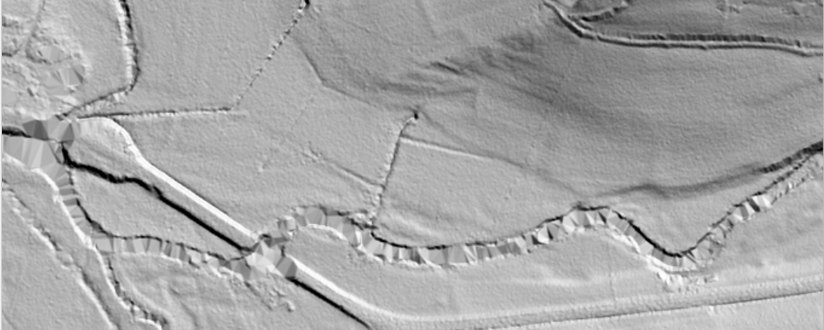
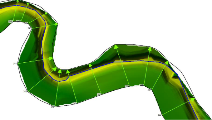
We will therefore have to work on our DEM so that it correctly represents both the major bed and the bottom of the river bed, for a precise consideration of the capacity of the watercourse. For this, we can rely on cross sections, skilfully placed to properly represent the variations in the gauge of the watercourse, the breaks in slope, etc. Many tools now exist to recreate a digital bathymetric model representative of the profiles and following the route of the watercourse (HEC RAS and TUFLOW each have their own tools to do this from cross sections taken from 3D polylines for example).
- Difficulty n°2 - the size of the watercourses: the narrower the watercourse, the more difficult it may be to correctly represent its size via a 2D approach.
The smaller the watercourse, the smaller the 2D cells will have to be, with a direct impact on the calculation times, via the Courant criterion, already mentioned in our blog.
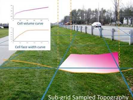
On this point, the softwares making it possible to exploit an approach called "infra meshes" or Sub Grid Sampling (SGS), will have an advantage: the meshes being able to take into account details of the topography whose dimensions are lower than the width of the cells, there is no longer any need to reduce these meshes too much to accurately represent small-scale elements such as narrow watercourses or even ditches. This sub-grid approach, managed in particular by HEC RAS and TUFLOW, even makes it possible to discretize roughness. The following article describes how this method works (illustration taken from the TUFLOW wiki).
- Difficulty 3 - hydraulic structures: most 1D models offer a fairly complete library of structures to represent any type of configuration encountered on watercourses (culverts, complex bridges, sluice gates, valves, etc.).
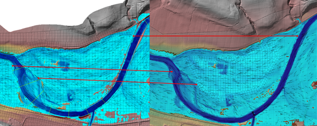
2D models now have the same capabilities, with sometimes even the possibility of going into more detail, on certain somewhat specific configurations. TUFLOW (see capture below, taken from the wiki) allows in particular a very fine consideration of the possible obstructions on a bridge, with an approach by layers, allowing to represent the obstructions related to the masonry, the parapets, etc...
On certain sufficiently wide watercourses, there may also be an interest in favoring the 2D approach, making it possible to differentiate the flows over the entire width of the structure, where the 1D approach cannot differentiate what it happens in the channel, or on the right or left banks of the watercourse.
HEC RAS is also well positioned on the possibilities of integrating structures within 2D, with fairly complete possibilities. A small downside, however, in the configurations where high speeds can be encountered, the pressure drops seeming to be significantly overestimated when approaching the structures.
 |
 |
- Difficulty n°4 - calculation times: the main downside of 2D models are calculation times which are, compared to 1D, much more important, especially on models relating to important linear of rivers.
This is particularly marked on HEC RAS, for which, despite parallelization on the processor (CPU), the calculation times quickly amount to days when models of several hundreds of thousands of meshes cells are run.
However, if we compare the cost of one day/engineer with the cost of calculation (machine time), the gain brought by the switch to 2D modelling, which is generally less time-consuming, if only on the time saved on model stabilization, is quickly very interesting from an economic point of view.
If, on the other hand, the deadlines are very constrained, the calculation time is a factor to be taken into account, especially when it comes to running several iterations for each simulation, in particular during the calibration phase of the models.
On this point, the various optimizations (on the mesh, with the SGS approach, and hardware with parallelization on the GPU graphics card) give the advantage to solutions like TUFLOW, since the calculation times are generally reduced to a minimum of a factor of 10 or more, making it possible to multiply the iterations, and thus improve the quality of the models, while reducing production times.
 advantage to the GPU computation
Some recent references on which we have implemented these approaches, to show that we practice what we preach:
- Modeling of the Semois (Belgium): about 40 km of full 2D modeling
Modeling of Suran (Ain): about 75 km of rivers modeled in full 2D
Modeling of a river in the south west of France: around 40 km of rivers in full 2D
And more references to come.
We propose training for the implementation of the approaches mentioned in this article, do not hesitate to contact us for more information.
Surface Libre is a distributor of the TUFLOW modeling solution in France and Benelux, more info on the tool here.